Technical advancements in embedded systems, sensing technology, and an understanding of the Earth's atmosphere have allowed us to deploy satellites for various applications. A more recent phenomenon is the use of low-Earth (<2,000km from Earth) and medium-Earth (between 2,000km and 35,000km from Earth) orbits to deploy smaller satellites called nanosats to perform applications such as surveillance, mapping, estimating sea levels and areas of forests and lakes. Most of these satellites use GPS to localize themselves. A unique challenge at the scale of a nanosat is that the size, weight, and energy required to run a typical GPS receiver might be more than what is affordable for long-term operation.
The work explored in the following paper focuses on the energy consumption of a typical GPS receiver and its operational challenges in a nanosat setting. The challenges include: power draw of a typical GPS receiver could be as high as 20% of overall power consumption; high-speed travel of nanosatellites (~7.8km/s) and relative speed to the GPS satellites (which themselves travel at 3.8km/s) makes getting a fix with a GPS satellite very challenging with high Doppler shift; lack of attitude control (typical of low power satellites) results in loss of GPS signal and corresponding loss in a fix; and, small delays result in large error requiring precise computation at low power.
The work explored in the following paper focuses on the energy consumption of a typical GPS receiver and its operational challenges in a nanosat setting.
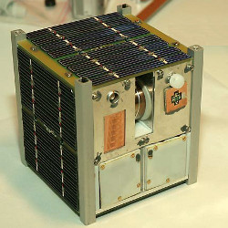
The authors solve these problems using two solutions. First, they designed a μ-GPS board to fit the size, weight, and power constraints of typical nanosats. The board is 40mm X 30mm X 2mm, weighs 20g and draws a max of 145mW. It is also designed to be robust to vibration and provides 10m location accuracy and 10cm/s velocity accuracy in the 99 percentile of measurements. It also provides time synchronization to the onboard computer and runs at 6mW in sleep mode.
Secondly, they designed the Fast Fix and Forward (F3) algorithm, which uses the μ-GPS board and provides requisite accuracy at the power budget afforded by the nanosat. It relies on heavy calibration prior to launch including loading the GPS almanac, TLE of the position in the predefined orbit and the time at that instant. In addition, the Time to First Fix (TTFF) is reduced by limiting the Doppler search using estimates of the GPS satellites' position and velocity. Finally, the time on the nanosat is synchronized with the GPS satellites by downloading one navigation frame. The authors also performed a detailed study of the duty cycling and its effect on power as well as accuracy and settled on a duty cycle time of 50 mins to provide a 10m location accuracy while consuming 120 J over five hours.
Overall, the nanosat application severely challenges assumptions that are made for typical GPS receivers. Requiring very low power due to small solar panels, the need to contend with high Doppler shift due to very high travel speed, lack of orientation control (which also changes at rotational speeds much larger than anything possible on Earth), and not having the same GPS satellites in view long enough to acquire a fix from a cold start are all unique to this application.
Some of these challenges might occur in other space applications as well. Space tourism has been in the news through flights by Virgin Galactic and Blue Origin. SpaceX and Elon Musk have touted the possibility of traveling from one end of the world to another (NYC to Beijing, for example) in 45 minutes by going above the current flight paths. Such near-Earth orbit applications could face the same issues with speed and visibility to GPS satellites as a nanosat. While they might not have low-power requirements, ideas from this work on limiting Doppler search as well as preloading information to use to limit TTFF might be useful as well. For terrestrial applications, it would always be interesting to reduce the TTFF. I suspect preloading a trajectory (when known) might be an easy add-on to current GPS receivers.
Finally, a major challenge for GPS receivers is when navigating in dense urban areas such as a large downtown. I wonder if fast acquisition combined with prior maps of a downtown area would be able to improve GPS acquisition in such scenarios?


Join the Discussion (0)
Become a Member or Sign In to Post a Comment